Equivalent clear cut area thresholds in extensively disturbed forests
Andrés Varhola (PhD completed)
For more than a decade, the lodgepole pine (Pinus contorta) forests of British Columbia have been affected by mountain pine beetle (MPB) (Dendroctonus ponderosae), constituting one of the most destructive insect outbreaks in North America. In such a snow-dominated environment, a receding forest cover is known to be associated with an increase in snow accumulation during winter, an enhancement in snowmelt rates and the suppression of transpiration during spring. These changes can exacerbate the risk of flooding, with the corresponding threats to infrastructure and society. However, the unprecedented extent of the disturbance (180,000 km2) and the particular nature of the beetles’ severe but gradual effect on the forests’ structural and physiological integrity have challenged scientists aiming to more confidently quantify the real ecological impacts.
Even though hydrologic models remain as the only tool currently available to evaluate the effects of MPB on snow and streamflow dynamics, they are impaired in their present form because they rely on coarse and oversimplified characterizations of forest structure unable to capture the changes caused by MPB on vegetation over large areas. This limitation has resulted from an enduring lack of systematic approaches to monitor forest structure metrics for their incorporation in hydrologic models. Remote sensing technologies such as Airborne Laser Scanning (ALS), which provides detailed three-dimensional representations of canopy structure, offer a remarkable alternative to fill this knowledge gap. The main objective of this thesis is to determine how hydrologic modeling can be improved by remote sensing —primarily ALS— by better characterizing forest structure in the interior plateau of British Columbia. Given the variety and complexity of hydrologic models, the same research question is applied independently to the simplest forms of plot-level univariate empirical models as well as complex physically-based simulators operating at the watershed level.
It was found that remotely-sensed forest metrics are better predictors of snow accumulation and ablation at the plot level than traditional ground-based variables, and that the accurate estimation of maximum snow accumulation and snow ablation with ultrasonic range devices significantly increases the quality of simple empirical models. It was also shown that a novel method, which minimizes the geometrical differences between ALS and traditional ground instruments’ data, was fundamental to obtain accurate plot-level estimates of forest structure metrics identified as primary drivers of snow processes. Finally, wall-to-wall watershed-level coverage of hydrologically-relevant forest variables was successfully achieved by integrating ALS metrics and Landsat spectral indices. The methods, tools and approaches developed in this thesis will result in more accurate and appropriate inputs for hydrologic models with the potential to significantly improve the quality of snow process and streamflow predictions.
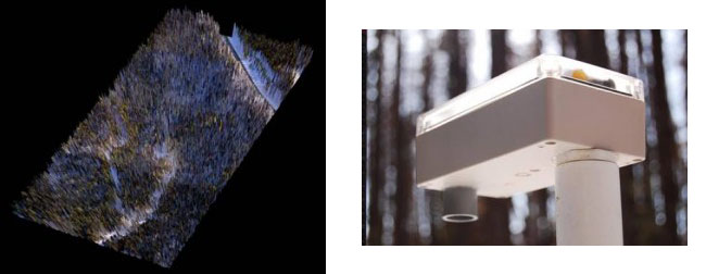
The innovative tools for this research correspond to LiDAR technology (laser scanning that can derive forest structure metrics) which can be combined with aerial photography to elaborate 3-D illustrations of the forests (picture in the left), and prototype sensors that continuously measure snow depth, air temperature and humidity (picture in the right).