Multi-scale Assessments of Forest Disturbances for Carbon Modelling
Vanessa S. Mascorro (MSc Completed)
Regardless of their origin, natural or anthropogenic disturbances are some of the main drivers that shape the forests over time and space, by altering their structure, composition and functioning. Understanding how natural disturbances and human activities impact the forest ecosystems is not only crucial for forest management, ecosystem services and biodiversity conservation, but also for climate change mitigation and adaptation. As forests have the ability to sequester large amounts of carbon through plant photosynthesis, they can contribute to offset the growing concentrations of CO2 in the atmosphere, storing it for long periods of time. Consistent, spatially explicit information is therefore essential to characterize the effects of forest disturbances on the land cover change. While increasing efforts have been made to address these needs, additional research is required to distinguish mapping observations by disturbance type. Satellite observations are a critical component to conduct such studies, due to their ability to detect patterns of the landscape and identify forest attributes over a range of spatial scales. Furthermore, recent studies have shown that results can be greatly improved when these data is integrated with other geospatial sources.
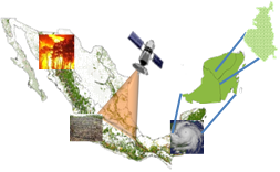
The main goal of this research is to develop consistent methodologies to assess forest disturbances at various spatial scales for carbon budget models in Mexican forest ecosystems. To attribute the cause of disturbance, remote sensing products are integrated with ancillary data from national forest inventories and other sources. Land cover change is then derived at different spatial resolutions, from MODIS and Landsat imagery. Multiple datasets are then overlaid with the land cover change to help attribute the disturbance cause and extent. Finally, annual disturbance maps are produced to provide input data for carbon budget models to quantify greenhouse gas emissions and removals. This endeavor will support Mexico’s efforts to improve monitoring, reporting and verification (MRV) aimed to support policy and decision making regarding climate change.
Linking forest attributes and their recovery to time series of remotely sensed data across unmanaged Canadian boreal forests
Ryan Frazier (PhD Completed)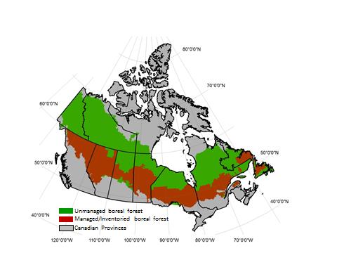
Boreal forests are important areas for global carbon storage, and Canada has 20% of the world’s Boreal forests. However, only a portion of the boreal forests in Canada are managed for timber and subject to regular forest
inventory practices. These inventory practices are able to provide information on various forest attributes which can then be used to understand the amount of biomass in a given area. While this may be possible for forests that are further south and closer to human populations, the northern boreal forests are unmanaged and noninventoried, leaving a gap in what we know about forests.
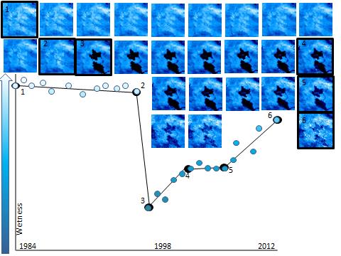
The Landsat series of satellites have been observing the earth continuously for more than forty years. The archive collected of imagery offers unique possibility to understand landscapes through time. Ryan’s research focuses on the ability of Landsat data to estimate forest attributes in boreal forests. In order to do this, Ryan will search the Landsat archive of imagery to collect many images in order to create a time series of yearly observations. When viewed on a graph, changes and trends become visible. The abrupt changes and long term trends that describe the history of that area can be helpful when estimating forest attributes.
Estimation of photosynthetic light-use efficiency from automated multi-angular spectroradiometer measurements of coastal douglas-fir
Thomas Hilker (PhD completed)
 Global modeling of gross primary production (GPP) is a critical component of climate change research. On local scales, GPP can be assessed from measuring CO2 exchange above the plant canopy using tower-based eddy covariance (EC) systems.
 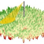 The limited footprint inherent to this method however, restricts observations to relatively few discrete areas making continuous predictions of global CO2 fluxes difficult. Recently, the advent of high resolution optical remote sensing devices has offered new possibilities to address some of the scaling issues related to GPP using remote sensing. Detection of GPP from remote sensing is based on the awareness that photosynthesis is related to the biochemical composition of plant foliage. This biochemical composition is being expressed in leaf spectral properties and can be detected from high resolution optical remote sensing instrumentation.
 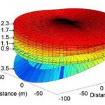 One key component for inferring GPP spectrally is the efficiency () with which plants can use absorbed photosynthetically active radiation to produce biomass. While recent years have seen progress in measuring using the photochemical reflectance index (PRI), little is known about the temporal and spatialrequirements for up-scaling these findings continuously throughout the landscape. Satellite observations of canopy reflectance are subject to view and illumination effects induced by the bi-directional reflectance distribution function (BRDF) which can confound the desired PRI signal.
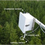
 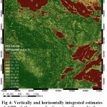 Further uncertainties include dependencies of PRI on canopy structure, understorey, species composition and leaf pigment concentration. The objective of this research was to investigate the effects of these factors on PRI to facilitate the modeling of GPP in a continuous fashion. Canopy spectra were sampled over a one-year period using an automated tower-based, multi-angular spectroradiometer platform (AMSPEC), designed to sample high spectral resolution data.