Project lead: Mike Wulder (CFS); rest of project team: Joanne White (CFS), Geordie Hobart (CFS), Txomin Hermosilla (UBC), and Nicholas Coops (UBC).
The Canadian Forest Service of Natural Resources Canada, partnered with the University of British Columbia, with support from the Canadian Space Agency, has been developing the science and methods to track and characterize the history of Canada’s forests. Using the Composite2Change approach, we applied spectral trend analysis to annual best-available-pixel (BAP) surface reflectance image composites produced from Landsat TM and ETM+ imagery. A total of 73,544 images were used to produce annual image composites from 1984 to 2012. These image composites enable to detect changes, identify the year in which the changes occur, and estimate a change type (such as harvest or wildfire). From the time series we can also assess the recovery of forests after disturbances by wildfire and harvest.
In this research, partnered with Foundry Spatial, we have developed an explore-and-discovery tool to portray and communicate forest change over Canada. The map shows the locations where forest change has been observed. The source Landsat imagery is a continuous surface of pixels, each representing a 30m x 30 m square area. For visualization purposes the change pixels have been converted to points, and generalized at different zoom levels.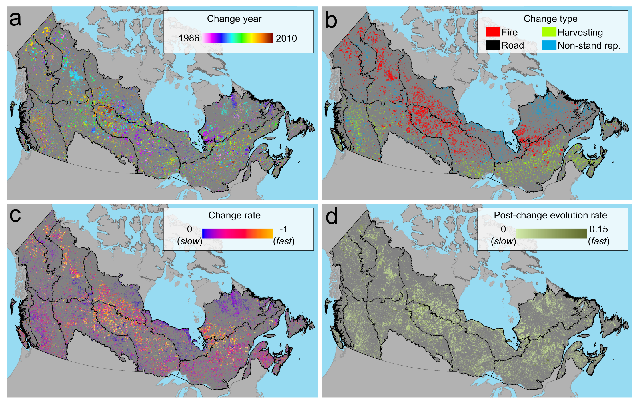
The accuracy of the change products was evaluated using independent validation data. Overall, change events were detected with a 90% accuracy. Fires were detected with a user’s accuracy of 98%, while harvesting was detected with a user’s accuracy of 88%. These results indicate that the automated change detection and attribution algorithms are robust, but errors will exist. Web tools such as this aid in visualizing and sharing results, but they are also designed to enable feedback that can further support refinement of the change detection and attribution algorithms.
Website:
http://forests.foundryspatial.com/
Publications:
Hermosilla, T., Wulder, M.A., White, J.C., Coops, N.C., Hobart, G.W., Campbell, L.B. 2016. Mass data processing of time series Landsat imagery: pixels to data products for forest monitoring. International Journal of Digital Earth. Open Access: http://dx.doi.org/10.1080/17538947.2016.1187673
White, J. C., Wulder, M. A., Hobart, G. W., Luther, J. E., Hermosilla, T., Griffiths, P., … & Guindon, L. (2014). Pixel-based image compositing for large-area dense time series applications and science. Canadian Journal of Remote Sensing, 40(3), 192-212. http://dx.doi.org/10.1080/07038992.2014.945827
Hermosilla, T., Wulder, M. A., White, J. C., Coops, N. C., & Hobart, G. W. (2015). An integrated Landsat time series protocol for change detection and generation of annual gap-free surface reflectance composites. Remote Sensing of Environment, 158, 220-234. http://dx.doi.org/10.1016/j.rse.2014.11.005
Hermosilla, T., Wulder, M. A., White, J. C., Coops, N. C., & Hobart, G. W. (2015). Regional detection, characterization, and attribution of annual forest change from 1984 to 2012 using Landsat-derived time-series metrics. Remote Sensing of Environment, 170, 121-132. http://dx.doi.org/10.1016/j.rse.2015.09.004
Chance, C. M., Hermosilla, T., Coops, N. C., Wulder, M. A., & White, J. C. (2016). Effect of topographic correction on forest change detection using spectral trend analysis of Landsat pixel-based composites. International Journal of Applied Earth Observation and Geoinformation, 44, 186-194. http://dx.doi.org/10.1016/j.jag.2015.09.003